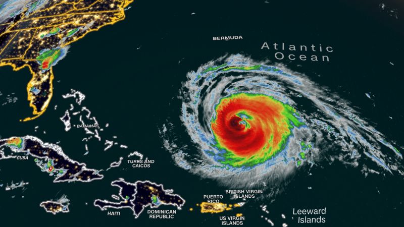
Hurricane Lee grew even larger on Tuesday and triggered a tropical storm watch for Bermuda as the cyclone’s potential impacts begin to come into focus for the island and beyond.
Lee, a Category 3 hurricane Tuesday afternoon, was centered about 535 miles south of Bermuda with maximum sustained winds of 115 mph, the National Hurricane Center said.
The storm has been growing in size since the weekend and hurricane-force winds now extend 125 miles from Lee’s center, according to the 5 p.m. ET hurricane center update. Tropical storm-force winds extended 240 miles from its core late Tuesday, having grown 55 miles in 12 hours.
Lee is expected to remain quite strong through Tuesday night, but will lose some intensity Wednesday into Thursday as it moves over slightly cooler waters churned up by Hurricane Franklin earlier this month.
But while Lee loses some strength this week, the hurricane will simultaneously continue to grow in size and begin to move faster.
A larger storm could impact a more widespread area, even if its winds no longer reach monster hurricane levels. A larger Hurricane Lee, then, is more likely to affect the Eastern Seaboard – even if not through a direct landfall.
Tropical storm-force winds could extend over 300 miles from Lee’s center later this week, National Hurricane Center Director Michael Brennan said in a Monday storm briefing.
This means potentially-damaging wind gusts could still impact portions of the northeastern US at the end of the week, even if the Lee’s center stays a couple hundred miles off the coast, out over the Atlantic Ocean. Tropical storm-force wind gusts could arrive for portions of Connecticut and eastern Massachusetts Friday night when Lee’s center is expected to be about 250 miles to the southeast.
The exact timing and extent of Lee’s winds and rainfall in the US and Canada could still fluctuate with lingering uncertainty over its track. But the hurricane’s track may come into better focus once it turns to the north Wednesday.
Regardless of its final track, the storm will send big waves to a growing area of the East Coast throughout the week as it tracks northward. This will cause coastal erosion, dangerous surf and life-threatening rip currents at beaches.
Dangerous surf was already happening along the southeastern US coast from Florida through the Carolinas and on many of the far eastern Caribbean islands as well as the British and US Virgin Islands, Puerto Rico, Hispaniola, the Turks and Caicos, the Bahamas and Bermuda.
A high risk of rip currents was in effect through at least Wednesday night for coastal areas from Florida northward to Massachusetts. Rip currents have already killed 71 people in the US this year, preliminary National Weather Service data shows. Three people in New Jersey died in rip currents kicked up in the wake of Hurricane Franklin last week.
Lee to sideswipe Bermuda before approaching US, Canada
Lee is expected to take a turn to the north on Wednesday and pick up its pace. The hurricane is set to make its closest approach to Bermuda Thursday into Friday and unleash strong winds and rain as well as dangerous surf and rip currents.
Late Tuesday morning, the Bermuda Weather Service Issued a tropical storm watch for the island, meaning tropical storm conditions are possible there in the next 48 hours.
Tropical storm-force wind gusts are likely to whip across Bermuda from Thursday morning into Friday as Lee passes to the west. Rain could also fall heavily at times during this period and may cause localized flash flooding.
Seas around the island will become hazardous with large waves as Lee approaches.


